The goal of this project is to develop a decision support tool that provides subseasonal forecasts of water availability for the Mekong River Basin using NASA’s subseasonal-to-seasonal (S2S) forecast system. Currently, the Mekong River Commission (MRC) forecast system provides 1-5 day river level forecasts along the Mekong’s main stem. The temporal and spatial scope of this forecast, however, is insufficient for comprehensive basin management, as it excludes river tributaries and hydrological alterations caused by reservoirs. Using well-established tools and published research by our team, this project will work directly with the SERVIR-Mekong hub to enhance the capabilities of their systems to:
1) Increase temporal coverage from 5 to 30 days;
2) expand spatial coverage to include Mekong tributaries;
3) accounting for reservoirs and their operations;
4) improve overall subseasonal forecast skill.
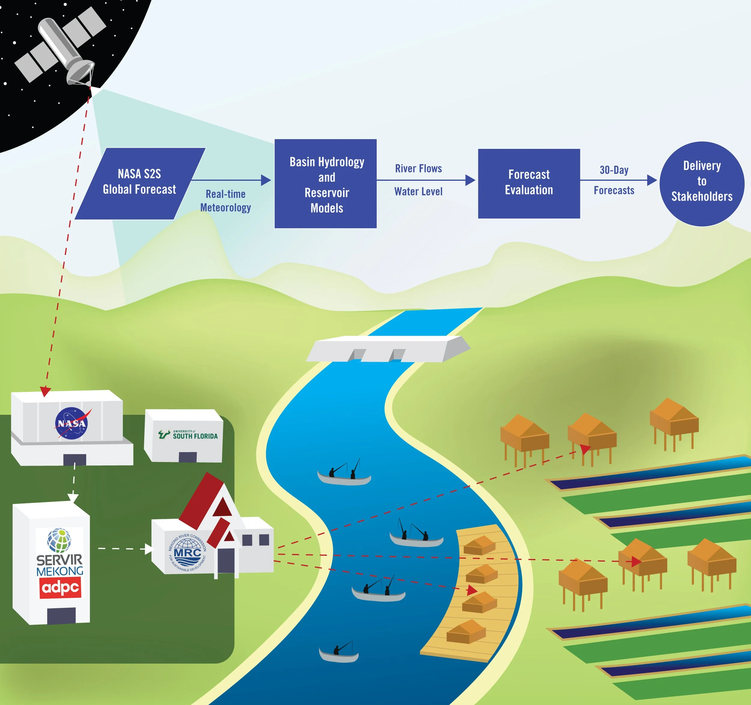
The proposed application builds upon published research and tools with high readiness level. At its core is the Global Earth Observing System real-time S2S forecast system by NASA’s Global Modeling and Assimilation Office. 30-day ensemble forecast meteorology from this system will be bias-corrected and used to drive NASA’s Catchment Land Surface Model offline. The resulting arrays of total water runoff will be used within our team’s well-proven reservoir model, which accounts for infrastructure and operations of major dams along the Mekong and its tributaries. Resulting forecasts of water discharge and levels at multiple locations throughout the basin will be shared with the MRC and other critical stakeholders through an online application co-designed with the SERVIR hub. The application of this project will be guided by SERVIR’s Service Planning approach and a Theory of Change, with feedback from MRC and other key regional stakeholders. This process will be facilitated through a series of 3 stakeholder workshops.
The primary thematic service area of this project is Weather and Climate. By developing a reliable, basin-wide subseasonal forecast, this project will produce a tool that generates actionable knowledge to National Mekong Committees, governmental and non-governmental organizations, the media, and the public. The proposed application would be instrumental in all other thematic services areas; in particular, it will help in drought resiliency, dam safety, hydropower production, and it will help maintain water needs of riverine ecosystems. It should also give disaster preparedness centers more time to plan emergency relief operations to protect life, property, public health and safety. Moreover, the application could help farmers, for example, reach short- and medium-term decisions about crop types and planting schedules, potentially resulting in larger and more profitable crop yields. In a broader sense, by boosting disaster risk reduction and effective water resources management, accurate subseasonal forecasts should provide overall societal benefits and enhance economic prosperity.
The proposed activities will lead to two umbrella outcomes: 1) Integration of NASA’s S2S forecasting platform with well-tested water models for the entire Mekong River Basin; 2) Prediction of subseasonal variations in river flows on the Mekong’s main stem and tributaries through the joint consideration of S2S forecast runoffs and dam operations. Proposed deliverables include application integration, validation and demonstration, 3 stakeholder workshops, scientific publications, and a online application compatible with existing SERVIR and MRC tools. Our project team consists of a diverse group of experts with a solid record of contributions to the Mekong’s state of knowledge, and a history of collaboration on applied research related to modeling land surface processes, watershed hydrology, reservoir operations, water resources management, seasonal forecasting, and stakeholder engagement.